Beira Alta and Beira Baixa
This is a region of extreme contrasts, incorporating the Serra da Estréla (the highest mountain range in Portugal), areas of sheep and cattle, and sturdy castles.
Main Attractions
The provinces of Beira Alta and Beira Baixa, the Upper and Lower Beiras, constitute a large rural section of eastern Portugal – a modest and hardy geographical region in a country that is among the poorest in western Europe. But it is rich historically, marked over centuries by the invasion routes of both Spaniards and Moors, in defensive castles and remnants of fortresses. The area has its natural attractions as well: the dramatic mountains of the Serra da Estréla and the stark plains and plateaux of the Baixa are some of the most beautiful natural landmarks in Portugal. The region is bounded by the Spanish frontier to the east, the Rio Douro to the north, and the Tejo (Tagus) to the south. The western boundary is a ragged line 60km (38 miles) east of Oporto.

Beira Alta farmer on his way home.
Lydia Evans/Apa Publications
Beira Alta
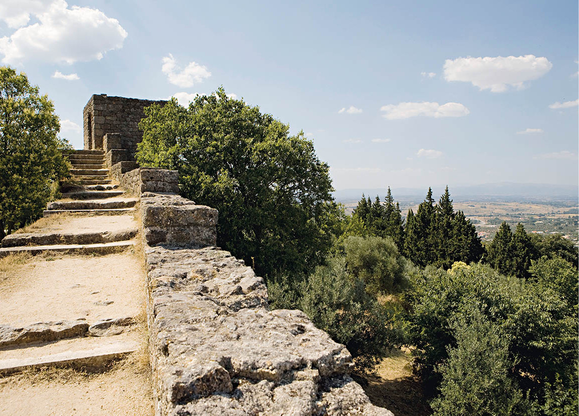
Guarda 1 [map] is the principal city and administrative capital of the Beira Alta’s eastern district. The charter of Guarda was granted by Sancho I, Portugal’s second king, in 1199, although the city had been established by 80 BC when it had a role in the attempted secession from Rome. Roman ruins can be found just outside town, near the Romanesque chapel of Póvoa de Mileu, notable itself for a small rose window and nicely carved capitals. Three town gates from the 12th- and 13th-century castle and town walls still stand: the Torre de Ferreiros (Blacksmiths’ Tower), the Porta da Estréla (Star Gate), and the Porta do Rei (King’s Gate), along with the castle keep. From the top there is a magnificent view of the mountains, and the broad plains to the north.
The Sé (Cathedral) was built of granite cut from the surrounding area. Work started in 1390 and was not completed until 1540, so that there were many Renaissance and Baroque elements added to the original Gothic. Diogo Boytac (1494–1520) worked on the cathedral, which bears some resemblance to Batalha. The exterior has flying buttresses and fanciful gargoyles. Inside, the 16th-century stone retábulo, later highlighted with gilt, represents scenes from the life of Christ; the stone carving is the work of João de Ruão, also known as Jean de Rouen (1530–70). A beautiful Renaissance doorway, off the north aisle, leads to the Capela dos Pinas, which contains the late Gothic tomb of a bishop.
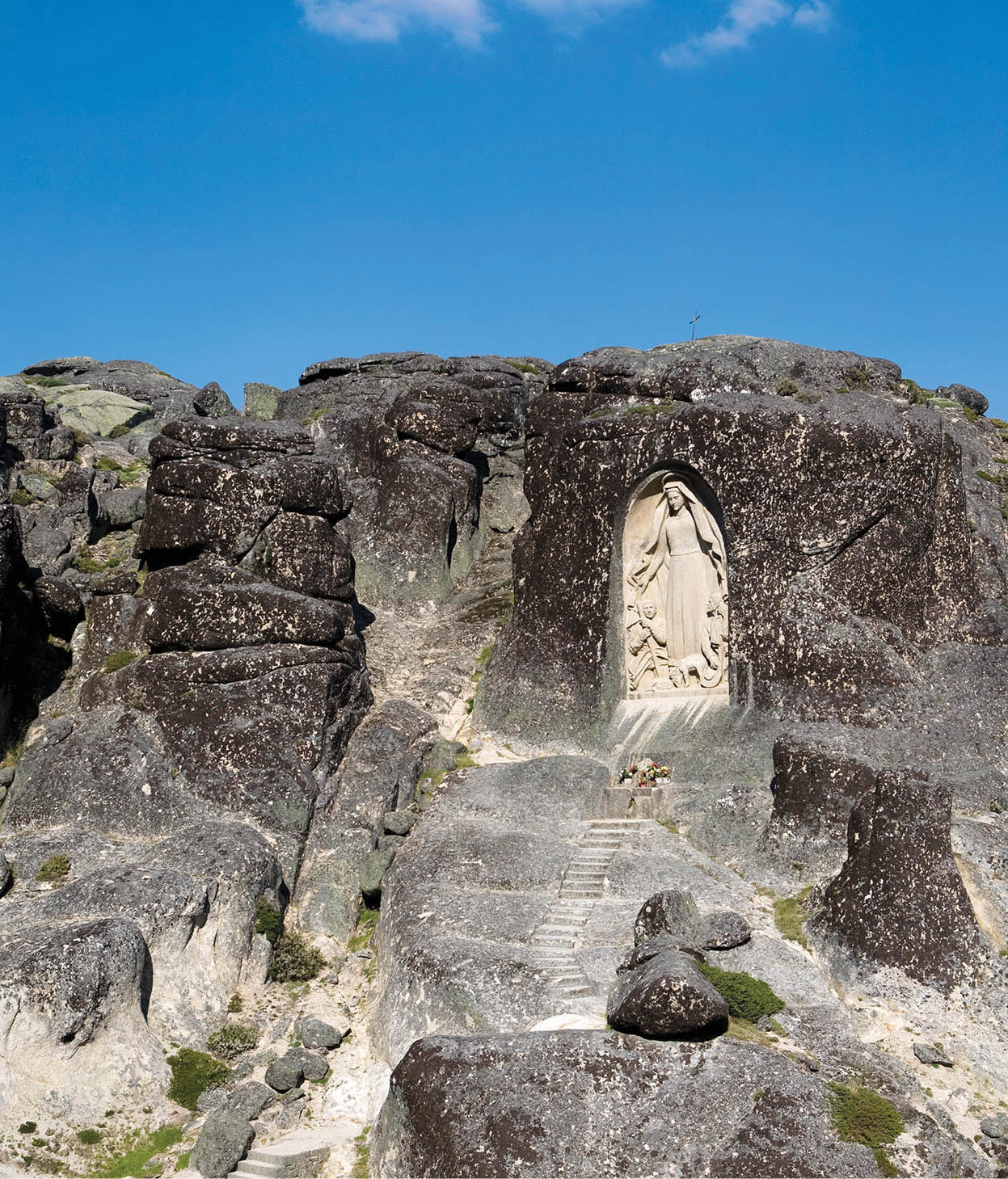
A shrine high in the mountains.
Lydia Evans/Apa Publications
The town museum in a 17th-century seminary has archaeological finds and a range of paintings, while a large park by the station includes an excellent, modern children’s playground.
Guarda has been dubbed the city of four Fs – fria, farta, forte e feia, which means: cold, plentiful, strong and ugly. The predominance of heavy grey granite may be ugly to some, but the old parts of the city are pleasant. “Strong” in this context alludes to Guarda’s history as a defence point against the Moors and Castile. “Plentiful” refers, no doubt, to the rich land surrounding the town, noted particularly for its sheep farming. Cold it certainly is, in winter: situated some 1,066 metres (3,500ft) above sea level, Guarda is Portugal’s highest city – high enough for frost and snow in winter.
Around Guarda
Northwest of Guarda is the quintessential fortress village of Trancosco, a delightful tangle of cobbled lanes surrounded by 13th-century walls. Don’t miss the castle with its unusual Moorish tower and the medieval juderia (Jewish district). South of Guarda lie two handsome castle towns: on the main road to Castelo Branco is Belmonte 2 [map], birthplace of Alvares Cabral, who discovered Brazil, and home to the Museu Judaico de Belmonte (Tue–Sun 9.30am–12.30pm, 2–6pm; free), portraying the fascinating history of Judaism in the town, and how it continued in secret some 500 years after the Inquisition. Just south of here is Sortelha 3 [map], a tiny village with a castle surrounded by rocky crags, within a “magic ring” of stone. Ancient civilisations may have shaped some of the rocks, and they certainly mined in the area – there are entrances to mines that have been closed for centuries.
Stretching southwest is the Serra da Estréla, the highest mountains in the country and the source of Portugal’s most highly rated serra cheese, whose production is centred on Covilhã (see below). The highest point of all is the over-commercialised Torre 4 [map], at nearly 2,000 metres (6,500ft). Nearby is a pilgrimage site, a statue of the Virgin carved into the rock, to which the faithful journey on the second Sunday of August.
Fact
The information offices for the Parque Natural da Estréla in Guarda, Seia, Gouveia, and Manteigas have details of hiking routes with places to stay.
The Serra offers skiing in winter and pleasant walking (or driving) with grand views in all directions. The prime winter resort is Covilhã 5 [map] , southeast of Torre. It is too low to receive much snow itself, but it is a short drive to the ski area at Penhas da Saúde 6 [map] .
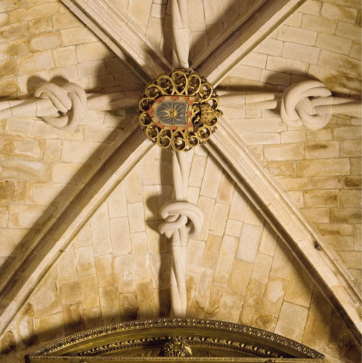
The exquisite vaulting in Viseu’s cathedral.
Lydia Evans/Apa Publications
Viseu: hub of Beira Alta
The western district of Beira Alta is governed by the city of Viseu 7 [map], about halfway between Guarda and Aveiro. In the 2nd century BC the Romans built a fortified settlement here, and some of their road system can still be seen, along with a number of Latin-inscribed stones.
A thorn in the side of the colonisers was a rebel Lusitanian named Viriathus, who harassed Roman legions until he was finally betrayed and killed. A monument to him lies at the edge of a park – the Cova do Viriato – on the site of a Lusitanian and Roman military encampment. Here, you can still see the old earthworks once used by the Romans. Viseu was made a bishopric during the 6th century AD, the time of the Suevian-Visigothic kingdom, and a record still exists: a signature of the Bishop of Viseu, dated AD 569.
The city suffered alternating invasions of Moors and Christians from the 8th to the 11th centuries. Fernando the Great of Castile and León captured it for the Christians in 1057. Teresa, mother of the first king of Portugal, granted the city its first charter in 1123. From the 14th to the 16th centuries, building in Viseu seems to have been concentrated in the upper part of town. About this time an active Jewish colony evolved here. In 1411 the Infante Dom Henrique (Prince Henry the Navigator) became Duke of Viseu, and towards the end of that century the town walls were completed. But the surrounding area was becoming a centre of vigorous agricultural activity, and by the 16th century the walled area was becoming depleted.
Perhaps this was fortunate, because over the next two centuries much of this space was filled with a lavish assortment of Baroque churches, chapels, mansions and fountains. Today the architectural richness lends a dignified air to the enclosed city.
Pure Baroque
A city highlight is the 13th-century Sé (Cathedral; daily 8am–noon, 2–7pm; free). The ribbed vaulting is beautifully carved to look like knotted cables, and the ceiling of the sacristy is extravagantly painted with animals and plants. The twin-towered Igreja da Misericórdia across the square is whitewashed granite and pure Baroque. You should also save some time for the Museu Grão Vasco (Wed–Sun 10am–12.30pm, 2–5.30pm, Tue 2–5.30pm), in the old Bishop’s Palace in the same square. Many of the works represent the fine school of Portuguese primitive painting that flourished here in the 16th century, and of which Grão Vasco Fernandes (for more information, click here) was the acknowledged master.
The Feira de São Mateus, held annually from mid-August to mid-September, is a major event in Viseu, with music, food and fireworks. A Tuesday market is held year-round. Viseu is well known for its lace, carpets and black pottery.
A cloudless day in Santar.
Lydia Evans/Apa Publications
Around Viseu
Northwest of Viseu is the small town of São Pedro do Sul and, some 4km (2.5 miles) southwest, the Termas de São Pedro do Sul 8 [map], which are probably the oldest as well as the best known and most frequented hot springs in the country. Sinus problems, rheumatism, hangovers or a foul temper – the springs are said to be a cure for all ailments. There are other delightful villages in the area, too. Just south of São Pedro do Sul is Vouzela 9 [map], with a lovely 13th-century church, and close by is the village of Cambra, clustered around the remnants of its castle.
South of Viseu, just off the secondary road to Nelas, Santar ) [map] is a little gem of a place, once known as the Court of the Beiras. Due south is Oliveira do Hospital ! [map], a small town that once belonged to the Hospitallers. As a mark of this, tombs of the Ferreiros in the parish church (the Igreja Matriz) are crowned by a carving of an equestrian knight on the wall above.
Southwest (continue down the main road in the direction of Coimbra), in the village of Lourosa @ [map], is the ancient church of São Pedro. Spain’s King Ordoño II ordered its construction in 911; it has a central nave, horseshoe arches, Moorish windows and Visigothic decoration.
Beira Baixa
Travelling south now towards the Beira Baixa, you come to the Rio Zêzere, which roughly divides Beira Alta from Beira Baixa. The river flows most swiftly from early April to late June. A good place for water sports is the Barragem de Castelo do Bode, a dam that blocks the flow of the River Zêzere to form a long, many-armed lake that runs south into the province of Ribatejo. (The most direct route is to take the IC3/N110, then turn left about 8km/5 miles south of Tomar.) Both the river and the lake have fine fishing, with canoeing, waterskiing and windsurfing available in places.
The Rio Tejo marks the southern limit of Beira Baixa. Upstream the Tejo crosses into Spain. On both sides of the border is desolate scrub country. The gorge formed by the river is steep-sided and virtually inaccessible for vehicles other than four-wheel-drives. Along much of the Portuguese side of the river runs an ancient Roman road, which was originally the route from Vila Velha de Rodão to the Spanish town of Santiago de Alcántara. Water now conceals large chunks of the work, but where the road rises above the surface, you will see that instead of building the road with flat stones, the entire way is paved with local slate stood on edge, its upper surfaces rutted by centuries of cart traffic.
Castelo Branco became a city in 1771.
Lydia Evans/Apa Publications
Castelo Branco
The capital of Beira Baixa is Castelo Branco £ [map], which stands at the junction of the IP2/E802 and the N112. It is an ancient city whose origins, like those of so many communities in Portugal, are lost in time. Its “modern” history dates back to 1182, when it and the surrounding area were given as a gift to the Knights Templar by Dom Fernão Sanches. It received a charter in 1213 and became a city in 1771, in the reign of José I. The battlements of the “white castle” that gave the city its name provide a fine view, though the castle itself is in ruins. The old town is delightful, with narrow winding streets. Points of interest include two churches, São Miguel and Misericórdia Velha, the latter a 16th-century structure with a notable doorway; and Praça Velha, also called Praça de Camões – a fine medieval square near the ancient municipal library.
The most important thing to see in Castelo Branco is the splendid Palácio Episcopal, built on the orders of the Bishop of Guarda, in 1596. It served as the winter residence of the bishops of the diocese. It now houses the Museu Francisco Tavares Proença Júnior (Tue–Sun Oct–Apr 10am–5.30pm, Apr–Oct 10am–7pm), which displays archaeological and regional items, but is most interesting for its large collection of colchas, the beautiful hand-embroidered bedspreads for which the town is famous.
In 1725, Bishop João de Mendonça commissioned a garden to be laid out beside Castelo Branco’s Palácio Episcopal. Although relatively small, it is considered one of Portugal’s finest formal gardens, and is an extraordinary sight, with a multitude of statues, fountains and pools. The statues have been placed in homage to just about everybody and everything the bishops thought important: the kings of Portugal, of course; the saints, Apostles and evangelists, along with the virtues; and the seasons of the year, the signs of the zodiac and the elements of the firmament. There were even more statues, but the invading French armies of 1807 carted off the best. The plinths have been left standing in their places, in many cases with the name of the missing item clearly engraved.

A Roman settlement was recorded at Idanha-a-Velha in the first century.
Lydia Evans/Apa Publications
Monsanto
From Castelo Branco it is easy to get to the small village of Idanha-a-Velha $ [map], northeast of the city. This was an episcopal see until 1199, when the see was moved to Guarda. There remains a strange, ancient basilica with dozens of Roman inscriptions inside. It is said that Wamba, the king of the Visigoths, was born here. A Roman bridge in the village is still in use, and various coins, pottery and bones have been found.

Giant boulder at Monsanto.
Lydia Evans/Apa Publications
Nearby is the granite village of Monsanto % [map], once declared “the most typical Portuguese village”, with many of its houses tucked between giant boulders. Built around and atop a steep rocky mass in a broad valley some 50km (30 miles) northeast of Castelo Branco, Monsanto sits in the middle of a major invasion route. Its intriguing castle commands a superlative view in every direction. It is thought that this monte has been fortified since Neolithic times, and the castle is so well integrated into the natural rock it looks as if it grew here.
Some say it was during the Roman invasion in the 2nd century BC, others claim it was some 1,400 years later during a Moorish invasion, that the people of Monsanto, under a long siege and nearly out of food, fooled their attackers by killing a calf, filling its belly with rice, and hurling it off the ramparts. The attackers were so impressed with the evidence of ample supplies that they packed up and left. One of the biggest feast days is on 3 May, when young villagers toss down pitchers filled with flowers from the battlements, symbolically re-enacting the event.
Much of the castle was destroyed at the beginning of the 19th century. One Christmas Eve there was a tremendous thunderstorm, and a bolt of lightning hit the gunpowder magazine. The gunpowder exploded, and the irons flew from the hearth and struck dead the governor, an unpopular figure who that year had forbidden the traditional burning of a tree trunk in front of the parish church. Divine retribution, the people of the village believed.
The folk music of the Monsanto area is charming if strange. Half chanted, half sung, there is nothing quite like it elsewhere in the country. Its rhythm is beaten out with the assistance of a square tambourine known as an adufe.
The great Idanha plain stretches south from here, beyond Castelo Branco, where there are large areas of pine and eucalyptus. It is a vast area of cattle-raising country: bitterly cold in winter, scorching hot in the summer months, it is not a region that is much visited by tourists.
Colchas
If you have been impressed by the beautiful linen bedspreads you saw in the museum, or those being made in the attached embroidery school, you might be inspired to buy a modern version to take home with you. Since the 17th century it has been the custom for brides-to-be to hand-embroider their wedding bedspreads. From this practice and skill, a cottage industry was born. Traditionally the spreads were white, but in recent years, they have become available in interwoven colours. Earlier patterns were geometric, echoing Persian carpets, but other decorative themes have become popular as well, including those showing flowers and birds. The intricate work involved means that a single item can take up to a year to complete, and prices are accordingly high.
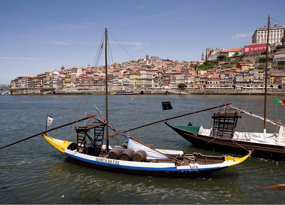
Porto, as viewed from the Douro river.
Lydia Evans/Apa Publications